New Technologies Accelerate Research on Watercourses and Mining Areas
Emerging methods are transforming how watercourses and mining sites are studied. Drone-based solutions and advanced measurement technologies offer fast, cost-effective, and safe approaches for mapping river channels and mine waste and water facilities. These methods provide increasingly precise data to support the restoration of aquatic ecosystems and risk management in mining environments.
The condition of Finland’s rivers is concerning. Up to one-third of rivers are in less than good ecological status. Natural, undisturbed rivers and streams are now rare outside Lapland—and even there, many have been modified for flood control, hydropower, and land drainage. Such interventions have degraded water quality and habitats, particularly for endangered migratory fish species.
In the mining industry, understanding riverbed morphology is essential even before operations begin. Riverbeds are often reshaped for future activities, and treated mine water is discharged under permit into natural watercourses. Although water flows downstream, complete mixing may occur several kilometres from the discharge point. This makes knowledge of riverbeds and flow conditions critical for correctly positioning discharge outlets and minimizing harmful impacts on aquatic life.
Mine sites also contain mine ponds (i.e. tailings ponds, waste heaps, settling ponds, water reservoirs) which structural integrity is central to environmental risk management. These pond bases consist of multiple layers and a robust liner. Recent environmental accidents in Finland have been linked to failures in these structures. Current inspection methods do not reliably reveal their condition, meaning leaks and weak points are often detected after delay.
Challenges of traditional riverbed and mine pond mapping
Improving the ecological state of watercourses requires restoration measures based on accurate information about current conditions and habitat structures. Assessing restoration needs demands detailed data on flow dynamics, riverbed and bank topography, and vegetation. Modelling water flow in riverbed is essential both for habitat simulations and for predicting pollutant dispersion.
However, traditional mapping methods are often slow, labour-intensive, and hazardous—especially in difficult terrain or unstable mining areas. The complex shapes and structures of riverbeds and mine ponds call for more efficient techniques that enable three-dimensional modelling of water flow and bottom structures.
Drone-based solutions and new measurement technologies in the UOMARI project
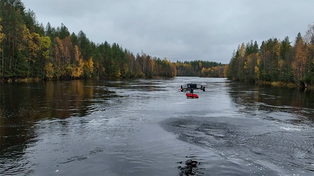
The project New Technologies for Mapping Riverbeds and Mine Ponds (UOMARI) develops drone-based measurement and imaging solutions applicable to diverse environments. Test sites include mining areas, regulated rivers downstream of power plants, and natural riverbeds. At the same time, these new methods are benchmarked against traditional approaches.
The project employs several complementary technologies. In laser scanning (LiDAR), the project is reportedly the first in the world to test a dual-wavelength drone-mounted LiDAR system combining green (bathymetric) and near-infrared (topographic) wavelengths. This enables simultaneous mapping of underwater and topographic structures.
Ground-penetrating radar (GPR) is used to investigate the bottom structures of the mine ponds and riverbeds. Traditionally, GPR surveys have been conducted on foot or from boats—a slow and potentially hazardous process, especially in old mining areas. Drone deployment makes these measurements both safer and faster.
Thermal imaging (FLIR) detects temperature differences useful for monitoring groundwater discharge and contaminant transport. An RGB camera provides high-quality imagery for mapping and enables flow calculations based on video analysis. Additionally, an autonomous survey raft equipped with sonar and multiparameter sensors supports water flow modelling and structural assessments.
The UOMARI project also advances data integration, combining imagery from multiple sources into a unified dataset. Merging bathymetric and topographic LiDAR in a single system enables seamless 3D mapping of underwater and terrestrial features.
Broad benefits across industries
Drone-based solutions can produce accurate 3D models of rivers and mine ponds, develop habitat models for migratory fish, and model the mixing of industrial effluents to optimize discharge outlet placement. These methods are cost-efficient, fast, and safe, enabling broader and more detailed surveys than before.
These new technologies improve planning and monitoring of watercourse restoration and reduce industrial environmental impacts, supporting the objectives of the EU Water Framework Directive and the Restoration Regulation. Drone-based solutions also enhance occupational safety by reducing the need to work in watercourses or difficult terrain.
Beyond mining and riverbed sites, these methods can be applied in permitting for water construction projects, dredging plans, structural assessments for power plants and bridges, lake sediment studies, and mapping of landfill seepage water.
Geological Survey of Finland GTK coordinates the UOMARI project. Partners include the Measurement Technology Unit (MITY) at the University of Oulu, the Finnish Environment Institute (Syke), and the National Land Survey’s Geospatial Research Institute FGI. The main funder is ELY Centre for North Ostrobothnia through EU Environmental ERDF funding for Northern Finland.
The project concludes in March 2026, but the aim is to share these new research technologies with end-users, such as mining companies, consulting firms, and measurement service providers, through industry collaboration. UOMARI project partners include Hannukainen Mining Oy, Otanmäki Mine Oy, Mitta Oy, Geo-Work Oy, Radai Oy, and Finnish Energy.
Writer
Kaisa Turunen, Research Scientist
Geological Survey of Finland GTK
kaisa.turunen@gtk.fi
Introduction to the project on GTK`s website: Novel Technologies for Stream Channel and Mining Pond Mapping – UOMARI Project

![]()