Science Blog: Geological and groundwater flow model of a submarine groundwater discharge site at Hanko (Finland), northern Baltic Sea
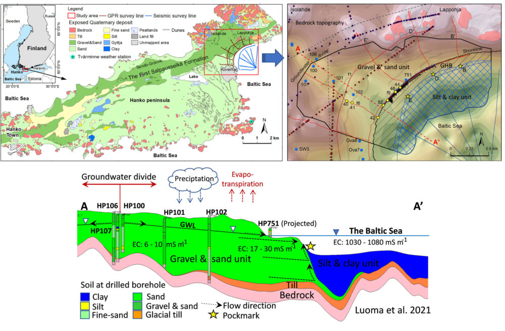
Submarine groundwater discharge (SGD) is the flow of groundwater from the seafloor to the coastal sea. It has been observed as a source of nutrients, trace metals and other potentially harmful substances from land to coastal ecosystems. In Finland, Virtasalo et al. (2019) discovered the first SGD site in Hanko-Lappohja, northern Baltic Sea, which is connected to the First Salpausselkä ice-marginal formation (SSI) and is associated with pockmarks on the seafloor.
Shallow groundwater in Finland typically resides in the thin overburden of late Pleistocene and Holocene glacial and post-glacial sediments that immediately overlie the Precambrian crystalline bedrock. These groundwater areas are hydrologically complex with heterogeneous sedimentary cover, including till, glacioaquatic gravel and sand, glaciolacustrine and post-glacial silt and clay, and in some areas, reworked littoral gravel, sand and clay. Major glaciogenic landforms with coarse-grained sediments are important groundwater reservoirs in the region, including the First Salpausselkä ice-marginal formation (SSI), which continues for tens of kilometres along the Hanko Peninsula on the south coast of Finland, and to the Baltic Sea.
During the BONUS SEAMOUNT project (2017–2020, jointly funded by the EU and the Academy of Finland), various methods were developed to estimate SGD flux rates. Among those methods, numerical groundwater flow models were developed as a means to estimate and predict the SGD and associated fluxes under current and future conditions. Three-dimensional (3D) geological models represent the geometry and stratigraphy of depositional sequences and provide the geological framework for groundwater flow models. Successful estimates of the SGD and associated fluxes to the coastal sea by numerical flow modelling require good understanding of the 3D aquifer geometry, the distribution of porosity of the aquifer media and the groundwater flow pathways.
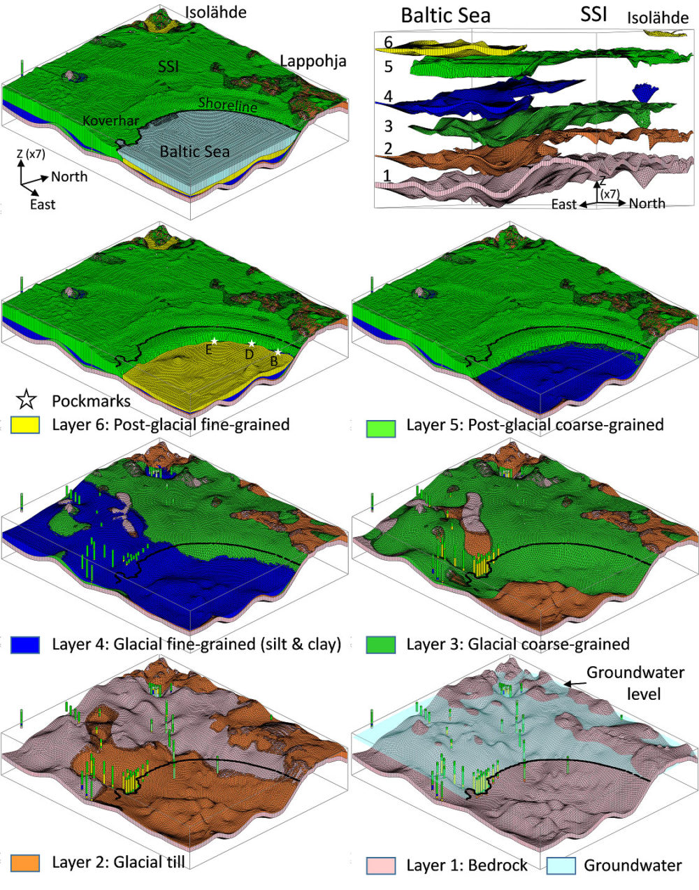
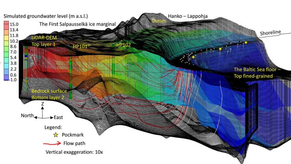
3D geological and groundwater flow models of the SGD site in Hanko were developed by integrating data from gravimetric, ground-penetrating radar and shallow seismic surveys, drill logs, groundwater level monitoring data, field observations, and a LiDAR digital elevation model. The 3D geological model was built under a geographic information system (GIS) platform and the 3D stratigraphic module in Groundwater Modelling System (GMS) software. The groundwater flow model was constructed by using MODFLOW and the particle tracking using MODPATH.
The geological model is constrained by the local geometry of Late Pleistocene and Holocene deposits, including till, glacial coarse-grained and fine-grained sediments, post-glacial mud and coarse-grained littoral and aeolian deposits. The coarse-grained aquifer sediments form a shallow shore platform that extends approximately 100–250 m offshore from the shoreline, where the unit slopes steeply seawards and becomes covered by glacial and post-glacial muds. Groundwater flow preferentially takes place in channel-fill outwash, coarse-grained sediments and sand and gravel interbeds, which provide conduits of higher hydraulic conductivity and have led to the formation of pockmarks on the seafloor in areas of thin or absent mud cover. The groundwater flow model estimated the average SGD rate per square metre of the seafloor at 0.22 cm/d in autumn 2017. The average SGD rate increased to 0.28 cm/d as a response to an approximately 30% increase in recharge in spring 2020. The total submarine groundwater discharge was estimated at approximately 773 m3/d in autumn 2017 and at 987 m3/d in spring 2020. These values, however, are modest compared to the estimated annual average direct groundwater discharge from the whole Finnish coastline to the Baltic Sea, which is approximately 1 000 000 m3/d. Groundwater recharge has a significant contribution to the SGD rate, and an increase in precipitation in this region will cause greater SGD into the Baltic Sea. These findings provide useful information for the town of Hanko and local authorities for planning land use and sustainable groundwater resource management.
References:
Luoma S, Majaniemi J, Pullinen A, Mursu J, Virtasalo JJ (2021). Geological and groundwater flow model of a submarine groundwater discharge site at Hanko (Finland), northern Baltic Sea. Hydrogeology Journal, https://doi.org/10.1007/s10040-021-02313-3
Virtasalo JJ, Schröder JF, Luoma S, Majaniemi J, Mursu J, Scholten J (2019) Submarine groundwater discharge site in the First Salpausselkä ice-marginal formation, south Finland, Solid Earth 10:405–423, https://doi.org/10.5194/se-10-405-2019
Figures:
Text: Samrit Luoma and Joonas Virtasalo
Samrit Luoma (Ph.D. Geology) is a Senior Scientist in the Water Management Solutions Unit in Espoo. She is a groundwater modeller and GIS expert at GTK. Since 2004, she has worked on several projects related to groundwater and environmental impact studies. Her research topics are focused on groundwater resource evaluation and vulnerability assessment under climate change with the integration of 3D geological and groundwater flow models, geochemistry and geostatistical analysis.
Joonas Virtasalo (PhD., dos. Marine Geology) is a Senior Scientist in the Marine Geology group in Espoo, GTK. He is a sedimentologist and (isotope) geochemist, and has worked on several projects related to the long-term development of the Baltic Sea ecosystem and seafloor processes.