Data from Below the Surface – Geosciences for the Baltic Sea
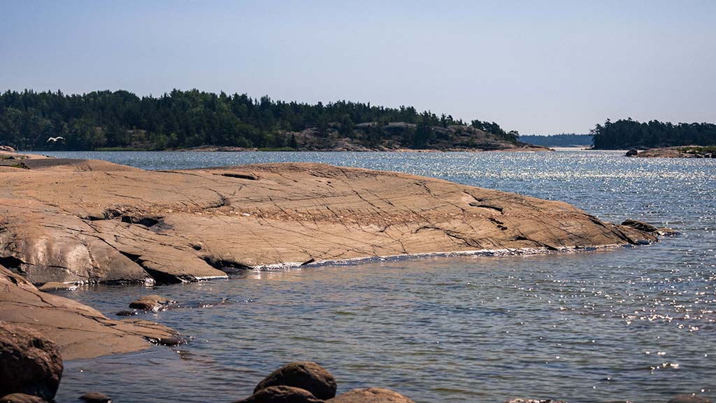
Every year, Baltic Sea Day reminds us that this shallow sea area relying on saline pulses is one of the most sensitive in the world – but also one of the most valuable. The Baltic Sea Day is an opportunity to stop and think about what we can do for the sea now and in the future.
The European Union is implementing an ambitious Restore our Ocean and Waters Mission to restore European marine and freshwater ecosystems by 2030. The Baltic Sea, together with the North Sea, is one of the four key areas designated by the EU to conduct the Mission, with a dire need of results.
It is important to note that this mission is not only aimed at researchers or authorities. The Mission invites us all to participate―citizens, businesses, municipalities and organisations. We all have the opportunity to exert influence, and that is why the Baltic Sea Day and the EU’s Ocean and Waters Mission have a natural connection.
Research in and health of the Baltic Sea are also an essential part of the operations and objectives of the Geological Survey of Finland GTK. In other words: how are geosciences, or information on the structure and functioning of the Earth and the sea, linked to the health of the Baltic Sea and supporting a common cause? Next, we will dive deeper into the three sub-objectives of the EU Mission and explain how research becomes practice and how geosciences support the achievement of mission objectives in the Baltic Sea.
Eliminating pollution: the Baltic Sea is polluted by many harmful substances
This summer, the Baltic Sea has not been able to avoid blue-green algal blooms; the most visible consequence of marine pollution. Blue-green algal blooms are a symptom of eutrophication due to excessive nutrient loading, especially phosphorus and nitrogen.
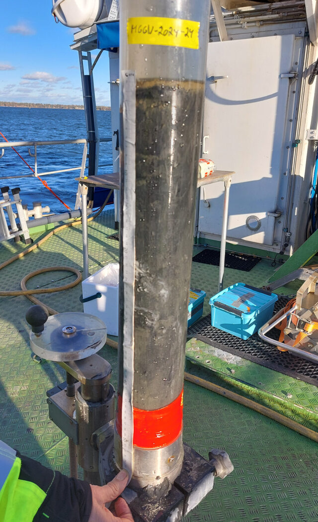
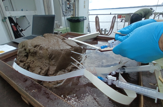
These nutrients enter the sea mainly due to agriculture and forestry and with wastewater. Phosphorus accumulated in the seabed is released back into the water, maintaining algal blooms year after year. Understanding the root causes and consequences of eutrophication is partly based on geochemical and sedimentological studies. These are conducted from catchment areas down to the depths of the sea.
In addition to eutrophication, the Baltic Sea is polluted by many harmful chemicals, such as old environmental toxic substances and heavy metals, as well as contaminants of emerging concern, such as microplastics and nanoplastics, PFAS compounds and pharmaceutical residues. Geosciences help us locate and assess the presence and spread of harmful substances in seabed sediments. Sediment surveys produce data on where and how harmful compounds are stored and where their concentrations may be the highest. This information is needed when planning measures to restore the sea and to target protection. Geosciences help us locate and assess the presence and spread of harmful substances in seabed sediments. Sedimentation surveys produce data on where and how harmful compounds are stored and where their concentrations may be the highest. This information is needed when planning measures to restore the sea and to target protection.
Senior Scientist Eero Asmala from GTK: “Seabed sediments are like nature’s own archive; they store not only the traces of thousands of years of climate and environmental change, but also the effects of human activity. This makes them an invaluable source for understanding the past. At the same time, it is important to note the substances stored in sediments, such as nutrients and harmful contaminants, when planning the use of the seabed, such as dredging and other measures.”
Restoring ecosystems: a healthy marine environment is built on geodiversity
The variability of the seabed, referred to as geodiversity, is as important as species diversity, as it lays the foundation for a healthy marine environment. GTK maps the geodiversity of the Baltic Sea with acoustic sounding and sediment analysis, among other measures. These research methods can be used to identify valuable habitats where species such as eelgrass (Zostera marina) and bladderwrack (Fucus vesiculosus) thrive. Information on the structures and characteristics of the seabed complements biological and ecological research and allows restoration measures to be targeted at where they have the greatest impact.
Geoscientific research also provides a long-term perspective: analyses of seabed sediments reveal how the conditions in the Baltic Sea have changed over time and what restoration measures can aim for. This helps us combine data on past changes with current action and future goals.
A good example of this is a study of groundwater-sea water mixing in the SecuCoast project, which produces new understanding of the state of coastal marine ecosystems and supports restoration.
Researcher responsible for the project, Senior Scientist Joonas Virtasalo from GTK: “The SecuCoast project studies the interactions between groundwater and sea water in coastal aquifers. Groundwater discharged to the sea carries carbon, nutrients and other substances, affecting the state of the marine environment, such as eutrophy and acidity, as well as the species composition of the seabed. On the other hand, sea water that intrudes in the aquifer lowers water quality. Climate change will change the interactions between groundwater and sea water due to increasing evaporation and heavy rainfall, and as a result of rising sea level and heavier flooding. The results of the SecuCoast project will help us better understand and manage the effects of human activity on the state of the marine environment and secure the availability of potable drinking water.”
Carbon-neutral blue economy in line with the circular economy
Offshore wind power and developing maritime infrastructure have been popular topics in recent years, as the clean transition requires introducing new carbon-neutral energy systems. Geosciences support the sustainable and responsible use of the seabed and coastal areas.
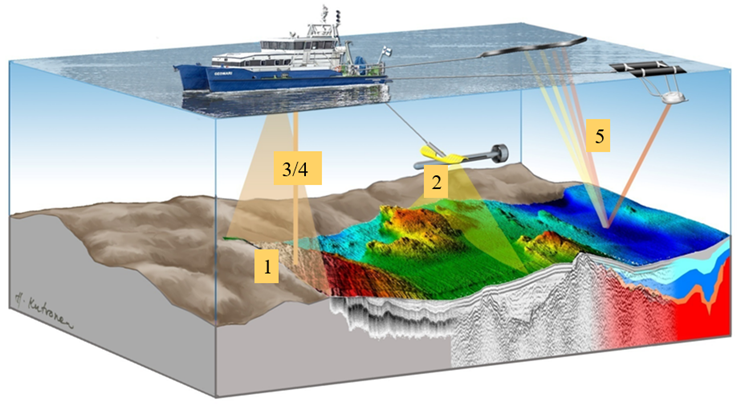
Safe construction of infrastructure at sea requires that the quality of the seabed and the thicknesses of the sub-surface sediment layers are known. The seismoacoustic surveys of the GTK research vessel Geomari allow mapping the distribution of different types of sediments and seafloor topographic features to provide an accurate visualisation of the seabed.
The collected geodata can be used to assess where offshore wind farms and their structures should be located and what type of foundations they require. Geodata also help us plan submarine cable routes and serve as background information for nature surveys. In recent years, GTK has been a partner in mapping offshore areas for wind power projects carried out by Metsähallitus.
Karoliina Koho, Head of Science and Innovations: “GTK is also involved in the Blue Mission BANOS CSA project promoting the EU’s marine mission. The objectives of the mission concern us all – from the state of the environment to food security and the future of renewable energy. For the mission to actually achieve its objectives, its progress must be closely monitored. In fact, a workable monitoring method and relevant indicators are developed in the project in cooperation with different stakeholders. The goal is to obtain reliable information on what has been achieved and where more measures are needed.”
Geoscientific expertise is useful in this work as well. Knowledge of seabed structures and understanding of water quality, sediment status and many other natural processes that affect both the marine environment and its sustainable use play a key role in designing the indicators. Well-planned monitoring not only measures successes but also helps us allocate resources correctly and makes the work transparent to decision-makers, researchers and citizens alike.
Geosciences are integral to the solution
The future of a healthy Baltic Sea depends on action based on research data. Geosciences make visible what would otherwise remain hidden: seabed structures and the risks and opportunities of the migration of substances of concern. Implementing the EU’s Ocean and Waters Mission requires intensive multidisciplinary cooperation, and Geosciences are one of its cornerstones.
The Baltic Sea Day is an excellent opportunity to stop and think about what kind of future awaits our Baltic Sea. The solutions are found in science, cooperation and everyone’s actions for the health of the Baltic Sea.
Writers
Eero Asmala
Karoliina Koho
Kristiina Nuottimäki
Lotta Purkamo
Further information
EU Mission: Restore our Ocean and Waters website
The SecuCoast project collects citizens’ observations on groundwater sources in the sea.
Participate in the study (in Finnish): SecuCoast survey
More information on the cooperation of GTK and Metsähallitus in mapping offshore wind power projects:
The Geological Survey of Finland Carries Out Seabed Soundings in Metsähallitus’s Offshore Wind Power Projects
BlueMission BANOS website:
Blue Mission Banos ‒ Supporting the EU Mission Restore our Ocean & Waters in the Baltic and North Sea
Project introduction on the GTK website:
BlueMissionBanos (BMB)
