Multi-Technology Approach Brings Greater Precision to Riverbed and Mine Pond Mapping
Drone-based and autonomous survey methods offer a new way to map watercourses and mining areas with greater precision, safety and efficiency than before. The UOMARI project developed and tested a multi-technology approach in which combining different measurement methods provides a more comprehensive picture of complex structures than any single technology alone.
In stream environments, restoration measures, flow modelling and habitat assessment require precise knowledge of riverbed morphology, bottom structures and their variability. In mining areas, the focus is on monitoring the condition of structures and managing risks. Traditional surveying methods are often slow and can pose occupational safety challenges in many sites. Moreover, they do not produce sufficiently accurate three-dimensional data on the complex geometry of riverbeds and mining structures.
The UOMARI project addressed these challenges by developing and testing drone-based and autonomous measurement and imaging technologies. Their suitability for different environments was also evaluated in comparison with conventional methods. The aim was to demonstrate that these new approaches can improve the accuracy and coverage of survey data while enhancing fieldwork safety and cost-efficiency.
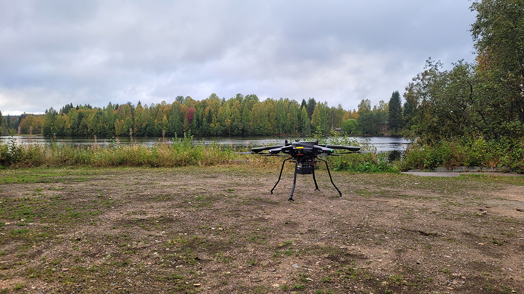
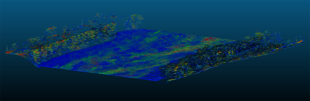
The project achieved this particularly well in difficult-to-access environments, such as riverbeds and mine sites, where measurements on foot or by boat would have been slow and potentially hazardous. Drones enabled rapid mapping of extensive areas and the production of dense point clouds and consistent three-dimensional models of riverbeds and mine ponds. River sections spanning several kilometres could be surveyed with only a few flights, clearly demonstrating increased efficiency.
Combining methods delivers the best results
The UOMARI project also examined the extent to which new technologies could replace traditional survey methods. The results showed that no single technology performs well under all conditions: water turbidity reduces the effectiveness of laser scanning, high electrical conductivity attenuates ground-penetrating radar signals particularly in mine ponds, and terrain obstacles can restrict the movement of drones and watercrafts in certain environments.
A key finding was the importance of combining different methods. Datasets produced by various survey techniques can be integrated to significantly improve the overall understanding of riverbeds or mine pond structures. In many cases, the depth and bottom structures in the central parts of riverbeds were best captured using ground-penetrating radar or echo sounding, while shoreline zones and above-water structures could be mapped accurately using laser scanning.
Integrating these datasets made it possible to produce unified and considerably more accurate three-dimensional models, thereby better supporting planning and restoration activities.
Mining environments combine drones, survey vessels and geophysics
In mining environments, the objective was to improve the monitoring of structures and the overall understanding of system conditions. The results indicate that drone-based methods are highly suitable for analysing the topography, erosion and deformation of dams and surrounding structures.
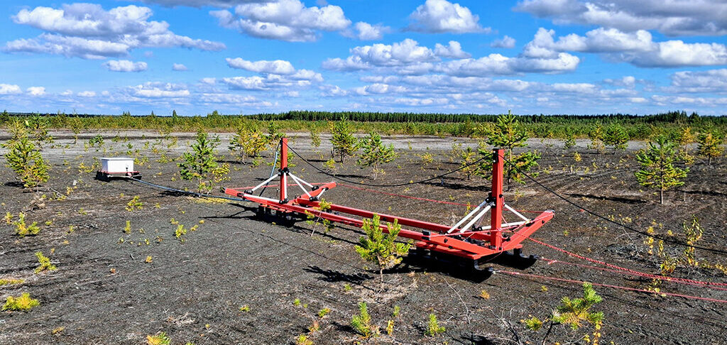
However, investigating internal structures in tailings and mine ponds using ground-penetrating radar proved challenging in many locations due to high electrical conductivity. In mine ponds, autonomous survey vessels proved to be an effective solution, rapidly producing reliable depth data. In tailings ponds, surveys were complemented with traditional geophysical methods such as GEM2 and tTEM measurements. Together, these methods improved the overall understanding of structures and their condition.
Methods are widely applicable across use cases
The methods developed in the UOMARI project were shown to have broad suitability. They can be used across a wide range of applications, including restoration planning for flowing waters, habitat and flow modelling, water infrastructure and dredging design, and environmental safety monitoring in mining and industrial areas.
The high-resolution spatial data produced by drones is particularly valuable for ecological analyses that require detailed information on habitat structure.
Overall, the objectives of the project were largely achieved. The research demonstrated that drone-based and autonomous survey methods can significantly improve the accuracy, safety and cost effectiveness of mapping. At the same time, it identified the limitations of individual approaches and highlighted the benefits of combining different technologies.
A key outcome is a practical operational model in which new technologies complement rather than replace traditional methods. This enables the production of more reliable and comprehensive data on the condition of riverbeds and mine ponds, supporting decision-making, planning and safety.
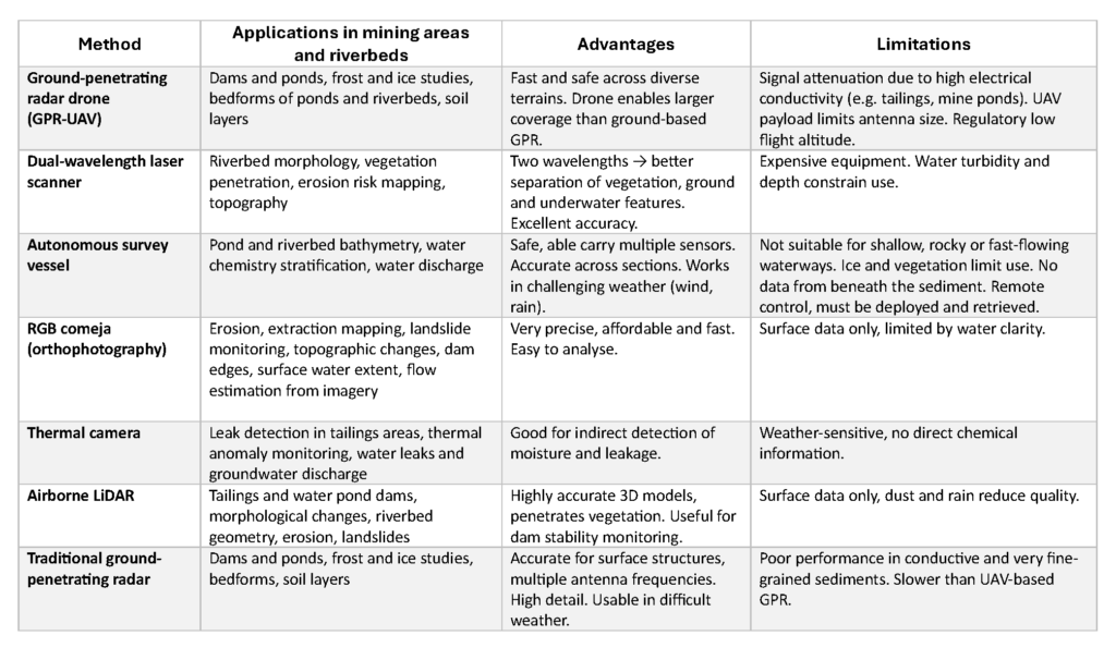
Table presents the advantages, limitations and suitable applications of the drone-based and autonomous survey platforms used in the UOMARI project.
Writer
Kaisa Turunen, Research Scientist
Geological Survey of Finland GTK
kaisa.turunen@gtk.fi
Introduction of the UOMARI project on GTK’s website:
Novel Technologies for Stream Channel and Mining Pond Mapping – UOMARI Project