Remote Sensing and Machine Learning Enable New Approaches to Mineral Exploration and Mine Site Monitoring
Remote sensing combined with machine learning can substantially increase efficiency in both mineral exploration and mine site monitoring, according to results from the Horizon Europe MultiMiner project. A major enabler is the drastic increase of freely available, open-source satellite data through the Copernicus programme of the European Space Agency. This data availability makes satellite imagery an affordable and effective additional information source for operational mining applications.
Rather than replacing fieldwork, these new approaches complement traditional methods by extending both spatial and temporal coverage. They support more targeted site investigations by helping to identify where detailed field measurements are required and improving the overall efficiency of exploration and monitoring activities on mine sites.
Recent years have seen the introduction of new free and commercial satellite sensors as well as drone-based technologies capable of providing hyperspectral and synthetic aperture radar (SAR) data. These imaging technologies are particularly well suited for sites with low vegetation cover. At the same time, advances in machine learning allow effective use of smaller numbers of field observations or samples, making the combined application of Earth observation and machine learning more accessible to the mining industry.
Toolset to enhance mineral exploration
In mineral exploration, the MultiMiner project developed a comprehensive toolset for analysing hyperspectral Earth observation data across multiple spatial scales. These tools support the mapping of surface mineral distributions, proxy minerals, and mineral vectors relevant to exploration activities. As part of this work, a dedicated spectral library was created to serve as reference datasets for mineral mapping of critical raw materials.
The methods were applied and validated through detailed mineral mapping case studies at Weißenstein and its surroundings in Austria, as well as in the Stratoni and Kallyntiri areas of Greece. The study sites focused on mapping regionally characteristic CRMs: magnesite in Austria, antimony in Kallyntiri, and antimony, gallium, platinum-group metals (PGMs), and bismuth in Stratoni. To facilitate practical uptake, user friendly software with a graphical user interface including guided workflows were developed, enabling use by industry professionals without requiring advanced technical expertise.
Operational mine site monitoring with improved coverage
For mine site monitoring, ground moisture monitoring methods were demonstrated at the Lappeenranta mine in Finland, operated by Nordkalk. Method development was led primarily by Technical Research Centre VTT and the Geological Survey of Finland GTK. The work focused on early detection of warning signs that may indicate and locate dam seepage associated with possible slope instability in tailings dams.
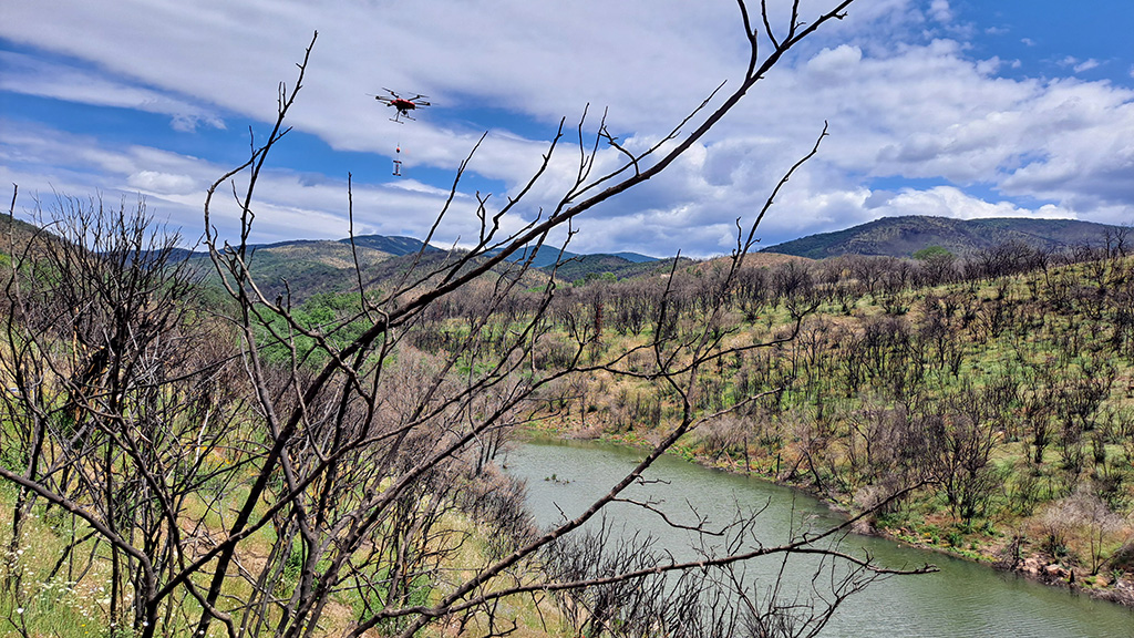
Key methodological innovations were the retrieval of near surface ground moisture using high resolution satellite SAR, multi band drone-based SAR data and a drone-carried electromagnetic measurement device, supported by extensive in situ measurements. The resulting combined method provides improved insight into weather related risks affecting operational tailings storage facilities and supports operational dust control on unvegetated surfaces.
Monitoring of open pit walls and tailings dams stability focused on tracking long term movements using interferometric synthetic aperture radar (InSAR). A major challenge addressed by the project was the impact of snow cover on InSAR processing and interpretation, which often leads to data gaps during winter. The resulting methodological advances significantly improved the reliability of InSAR interpretation under cold-climate conditions. This reduces dependence on extensive in situ deformation measurements and enhances the operational usability of InSAR-based monitoring, representing a substantial innovation in cold climate data interpretation.
Dust, vegetation and water quality monitoring
The project also developed a combined atmospheric and surface dust monitoring method, with the Czech Geological Survey (CGS) leading the development and testing the method at the Lappeenranta and Stratoni mines. By integrating satellite data with air-quality products, the method enables real time monitoring of atmospheric and surface dust, distinguishing between natural and anthropogenic sources. This supports timely mitigation measures and improves environmental compliance.
Vegetation monitoring focused on assessing plant diversity at the Weißenstein rehabilitated mine site. Using Sentinel-2 time-series data, plant diversity was estimated in rehabilitated grasslands and adjacent areas. This VTT led approach extends the spatial and temporal coverage of conventional ground surveys and supports consistent monitoring of rehabilitation progress, helping to prioritise further revegetation efforts.
Water quality and acid mine drainage (AMD) monitoring were demonstrated in northern Greece, at the abandoned Kirki mine site, with main development contributions from CGS, GTK and Hellenic Survey of Geology and Mineral Exploration (HSGME). Daily satellite imagery was used to fill spatial and temporal gaps of in situ measurements, enabling multi-scale detection of AMD discharge and associated mineral mixtures. The method allows early identification of changes in surface water quality, including indicators such as total suspended solids and arsenic concentrations.
Supporting consistent data use across sites
To support consistent application across sites, strong emphasis was placed on harmonising fieldwork and accuracy assessment practices. A dedicated database was developed to standardise the information of field and laboratory data acquisition.
The project results demonstrate that the principal gains of remote sensing and machine learning applications lie in efficiency: access to more comprehensive information, improved prioritisation of fieldwork, and better-informed decision-making in both mineral exploration and mine site monitoring.
Further information
Maarit Middleton, Research Professor, Scientific Coordinator of MultiMiner
Geological Survey of Finland GTK
maarit.middleton@gtk.fi
tel. +358 29 503 4345
Pauliina Liwata-Kenttälä, Geologist, Project Manager of MultiMiner
Geological Survey of Finland GTK
pauliina-liwata.kenttala@gtk.fi
tel. +358 29 503 4133
Get to know the MultiMiner project:
MultiMiner – Multi Source and Multi Scale Earth Observation and Novel Machine Learning for Mineral Exploration and Mine Site Monitoring
The Horizon Europe funded MultiMiner project developed novel data processing algorithms for cost-effective utilisation of Earth Observation technologies for mineral exploration and mine site monitoring. The project consortium included 12 European partners with Geological Survey of Finland GTK as the coordinator.

![]()
MultiMiner Results and Impact Summit 21–22 April 2026
The final results of the MultiMiner project will be presented in a free two-day conference and clustering event on 21–22 of April in Rovaniemi, Finland. Registration is still open with the option to participate online.
For press: Contact Pauliina Liwata-Kenttälä (see contact information above) for the international project group interviews in Rovaniemi on 21–22 April.
Register for the event