Etusivu ⟩ Tutkimus ⟩ Tutkimusprojektit ⟩ DroneSOM - Nopeampi mineraalitutkimus pienillä ympäristövaikutuksilla ja kustannustehokkaasti
DroneSOM – Nopeampi mineraalitutkimus pienillä ympäristövaikutuksilla ja kustannustehokkaasti
- Projektin tutkimusalue
- Geofysiikan sovellukset Geotiedon ratkaisut
- Projektin kesto
- 01.05.2022 - 31.12.2024
- Verkkosivusto
- https://dronesom.com/
Esittely
DroneSOM-projekti käynnistettiin vuonna 2022 ja on EIT Raw Materialsin rahoittama. Projektia johtaa Suomen geologinen tutkimuskeskus (GTK) yhteistyössä RADAI Oy:n, Tanskan teknillisen yliopiston (DTU) ja Beak Consultants GmbH:n kanssa. Projektin tavoitteena on kehittää useita innovatiivisia tuotteita, jotka vastaavat kasvavaan akkumineralien kysyntään. Drone-geofysiikka tarjoaa kustannustehokkaita, tarkkoja ja turvallisia tutkimusratkaisuja.
DroneSOM-projekti on kehittänyt innovatiivisia teknologioita geofysikaalisiin mittauksiin ja datan tulkintaan. Sisältäen kaksi dronepohjaista järjestelmää: toisen sähkömagneettisia mittauksia varten sekä maailman ensimmäisen painovoimamittausjärjestelmän. Projektissa hyödynnetään Radai:n sähkömagneettista anturia ja DTU:n korkean tarkkuuden inertiaalimittaria painovoimamittauksissa. DroneSOM tarjoaa integroituja ohjelmistotyökaluja dronella kerättyjen tietojen analysointiin. GTK:n 3D-geofysikaalinen inversio- ohjelmisto luo 3D-malleja, “GisSOM” yhdistää 2D-geofysikaaliset tiedot, paljastaen mineraaliesiintymien rakenteet, ja Beakin “advangeo® 3D Prediction” -ohjelmisto integroi volyymimittauksia kenttäaineistosta.
Dronet
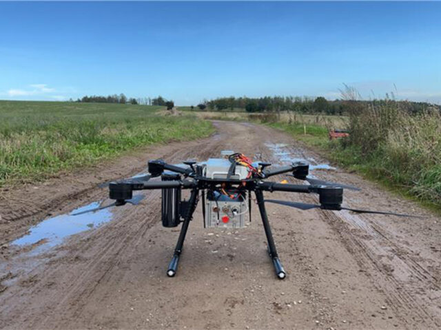
Radai oy on luonut kevyen sähkömagneettisen dronen nimeltä Louhi, joka koostuu EM-vastaanottimesta ja EM-lähetinyksiköstä (maasilmukka). Drone vetää vastaanottimenyksikköä, ja suuri lähetyssilmukka sijoitetaan maahan. Lähetysyksikkö luo sähkömagneettisenkentän (taajuusalue), ja vastaanottimenyksikkö (kolmiosainen järjestelmä) mittaa kentän ja toissijaisen sähkömagneettisenkentän summan. Mittauskentän komponenttien amplitudin ja vaiheen vaihtelut osoittavat poikkeavuuksia maaperän ja kallioperän sähkönjohtavuudessa. Lisäksi yhden ulottuvuuden inversio tarjoaa nopeita resistiivisyyskarttoja.
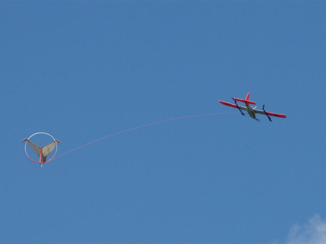
Viimeaikaiset edistysaskeleet painovoimamittauksissa dronen kanssa ovat avanneet merkittäviä mahdollisuuksia, vaikka lentosäännökset edellyttävät, että dronien siipiväli on alle 3 metriä ja kokonaispaino ei ylitä 25 kg. DTU Space on kehittänyt kaksi drone prtotyyppiä: kiinteäsiipinen drone, joka soveltuu iMAR-antureille 8 kg kuormalla, ja kopterimallin, joka on kohdannut haasteita, kuten virransyöttöongelmia ja moottorivikoja. Vaikka kopterin kokoonpano on lähes optimaalinen, se ei ole vielä kaupallisesti valmis.
|
|
|
Ohjelmisto
GTK kehittää 3D-taajuusalueen sähkömagneettisia inversiotekniikoita dronella kerättyjen aineistojen analysointiin. Nopeaa kehitystä on saavutettu geofysikaalisten 3D-inversiomallien kehittämisessä, jotka hyödyntävät äärellistä elementtimenetelmää, kaksinkertaista oktree-verkkoinversiota ja MPI-parallelisointia. Tulevaisuuden askeleet sisältävät iteratiivisten ratkaisijan luomisen, GPU-laskennan käyttöönoton ja sähkömagneettisten inversiomenetelmien parantamisen. Nämä tekniikat ovat onnistuneesti käsitelleet todellista dataa, ja niiden on suunniteltu soveltuvan dronen keräämään dataan seuraavien kuukausien aikana.
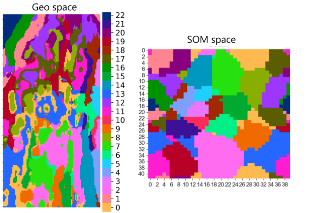
GTK:n “GisSOM”-ohjelmisto integroi 2D-paikkatiedot itseorganisoivilla kartoilla (SOM) ja k-means-klusteroinnilla, mikä auttaa käyttäjiä ymmärtämään datarakenteita, tunnistamaan klustereita ja visualisoimaan mineraalivarantojen tuloksia.
Beak Consultants GmbH:n “advangeo® 3D Prediction”-ohjelmisto yhdistää erilaisia 3D-tiedonkohteita uusien mineraalipotentiaalistatutkimuskohteiden tunnistamiseksi. Ohjelmisto tukee nyt 3D-tiedon klusterointia itseorganisoivilla kartoilla (SOM). Ennen ohjelmistoon oli jo implementoinut valvottuja ennustavia kartoituksia 3D:ssä käyttäen tekoälyneuroverkkoja (ANN). Ohjelmisto tarjoaa täydellisen työnkulun ennustavaan mallintamiseen ja sisältää tietokannan mallin suoritusten seuraamiseksi. Se on kaupallisesti valmis, ja sitä kehitetään jatkuvasti. 3D-geologiset mallit voidaan tuoda ohjelmistoon GOCAD:sta tai muista yleisesti käytetyistä 3D-mallinnusohjelmista, kuten voxeteista.
DroneSOM-tuotteet on suunniteltu kaivosteollisuudelle. Ne eivät keskity vain huipputeknisiin mittauksiin, vaan sisältävät myös tulkinnan osan, jotta prosessista voidaan luoda malleja käyttäen ML ja itseorganisoivia karttoja. Nämä ratkaisut hyödyttävät laajaa yritysjoukkoa, pienistä yrityksistä suuriin teollisuuden toimijoihin. DroneSOM-projektin menetelmät ovat ratkaisevan tärkeitä uusien resurssien löytämisessä ja uusien tulevaisuuden tutkimuskohteiden tunnistamisessa.
Seuraa meitä: LinkedIn ja dronesom.com
Projektikumppanit:
Projektilistaukseen